With a pronounced blocking high over northern Europe and parts of the Norwegian and Greenland Sea, this week’s weather will be quite uncommon over the North Sea. Even though high pressure is generally predominant, it doesn’t mean that the weather will always be conductive for all maritime operations. In the briefing below you will find the latest details for the upcoming week.
A vast area of high pressure initially stretches from Russia across northern Europe all the way into the Greenland Sea. The system slowly declines while the emphasis shifts towards Greenland from Wednesday onward. An associated ridge stretches southeast into Scandinavia by then. A shallow low on its southern flank affects the southern North Sea on Tuesday, slowly moving east afterwards. Once the low has dissipated over E Germany late Wednesday, aforementioned Scandinavian ridge builds south across the North Sea towards northern France on Thursday, slowly shifting E afterwards.
Due this synoptic pattern winds tend to come from directions between south and east throughout the week; generally remaining moderate to fresh (3 to 5 Bft). Only on Tuesday pretty strong easterlies are expected over large parts of the North Sea as aforementioned low comes in over the southern North Sea. Winds will likely peak at 6 or 7 Bft, gradually decreasing from Tuesday evening onward as the low moves east into the Netherlands and Germany.
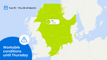
Significant wave height ranges between 2.5 to 4.0m over the central and northern North Sea on Tuesday. Given the easterly direction Thames and Dover will see lower waves as the Benelux will be sheltering off those areas. Afterwards waves slowly decrease to 1.0-2.0m everywhere on Thursday as the pressure gradient (and thus winds) gradually weaken in the course of the week.
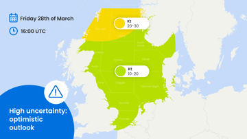
During the weekend pressure remains high in the far north, over Scandinavia and parts of the European mainland while a deep low develops over the Atlantic. The resulting southeasterlies then strengthen over the western North Sea with likely 6 Bft and Hs gradually increasing to 2.0-2.5m. Further east, along the outer fringes of aforementioned high, conditions will most likely remain calmer and more workable though.


