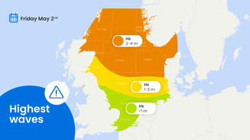
After a calm week, weather conditions are set to change. Calm conditions with low cloud and localised mist will persist on Tuesday and Wednesday. Winds will begin to increase on Thursday, with a significant rise in both wind and wave heights expected from Friday. This change is due to the passage of a deep low-pressure system.
The high-pressure system that has been affecting the North Sea in recent days has moved south-eastward towards SE Europe. However, conditions on Tuesday and Wednesday will remain unchanged, with calm, cloudy weather and mostly workable conditions.
A shallow frontal trough will pass over the North Sea later on Wednesday, followed by a deeper trough on Thursday. This second trough will bring higher winds, especially to the southern North Sea. Strong to near-gale south-westerly winds are expected in this region.
A significant increase in wind and wave activity is expected this coming weekend. A deep low-pressure system will move across the northern North Sea during the night leading into Saturday. Gale-force winds, including strong gale conditions, are anticipated over the entire North Sea starting Friday. Significant wave heights are expected to range from 3 metres in the Dover and southern Thames areas to more than 8 metres in the Forties and Viking regions.
Next week, new low-pressure areas are expected to affect the North Sea. More information about this will be provided in next week's North Sea briefing.


