After a week of stormy weather over the North Sea, the weather will slowly improve this week. This means that gradually more workable windows will appear later this week. However, the week will still start off quite unsettled, especially in the southern North Sea.
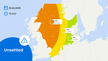
An extensive low-pressure system will be positioned over the Netherlands during the day on Tuesday, while a high-pressure system will be located over Scotland. Between these two pressure systems, there will be a strong east to northeasterly wind. This will result in sustained wind speeds of up to 35 kts and significant wave heights (Hs) peaking at 4m on Tuesday, particularly in the Fisher, Dogger, Tyne, Humber, and the northeastern part of the German Bight districts. Due to the shorter fetch further south, Hs will be limited to a maximum of 3m with winds of 25-30 kts (see Figure 1).
Further north, an extensive high-pressure system will bring much calmer conditions (see Figure 1). This high will move southeast over the course of the week, leading to calm weather across the entire North Sea from Thursday onwards. This calm weather is expected to persist at least until Saturday, providing a long workable window.
 Figure 1: Severe weather chart of the North Sea this week. The most active weather is expected over the southern parts of the North Sea on Tuesday and early on Wednesday.


