A weak frontal trough tracks over the northern North Sea on Tuesday. Meanwhile, a high pressure area over central Europe dissipates by Tuesday afternoon. At the same time, another high tracks over the United Kingdom approaching the North Sea by Wednesday lingering there until Thursday. The high slowly shifts E dissipating over the Eastern North Sea on Friday. Meanwhile, a low pressure area lingers S of Ireland and an associated trough influences the North Sea over the weekend. Several frontal trough track over western and central Europe from Tuesday onwards and associated thunderstorm activity may affect the southern North Sea at times.
What to expect this week?
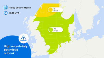
As the frontal trough tracks over the northern North Sea on Tuesday, winds up to 25-30 kts with gusts up to 30-35 kts are expected while the waves may increase up to 3-3.5 m. By the end of the day, the conditions over the northern North Sea improve due to the approaching from the SW high pressure area. As high pressure persists over the region well into Friday, the wind speeds, in general, will not go over 15-20 kts with gusts up to 20-25 kts. Significant wave height stays below 1.5-2 m as well. However, due to the funneling effect along the southern Norwegian coast, the winds over the area may increase up to 25-30 kts with gusts up to 30-35 kts while the waves may increase up to 2-2.5 m.Alongside, a frontal trough tracks over western and central Europe and low risk (10-30%) of thunderstorm activity is expected over the southern North Sea between Wednesday and Friday.
Unsettled conditions in the weekend
The trough of low pressure influences the North Sea over the weekend bringing rather uncalm conditions on Sunday. Winds up to 25-30 kts with gusts up to 35-40 kts are expected over the central and northern North Sea (see Figure 1). The waves may increase up to 2.5-3 m (see Figure 2). At the same time, the southern North Sea remains relatively calm where the winds will not go over 20 kts and the waves will stay below 2 m.
 Figure 1. Wind speed in knots according to the American GFS model on Sunday August 4th at 20 UTC.
 Figure 2. Significant wave height in meters according to the American GFS model on Sunday August 4th at 20 UTC.
More updates and insights like this? Subscribe to our newsletter and receive the latest articles in your mail.