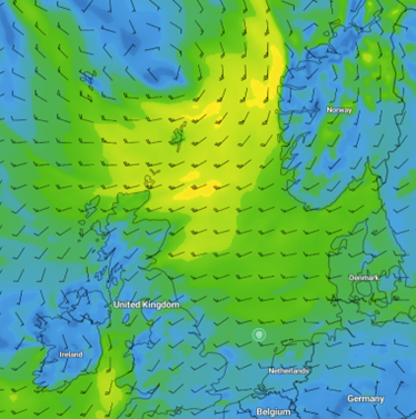
The weather over the North Sea is influenced by Atlantic low-pressure areas moving ENE via the sea area north of Scotland into the Norwegian Sea this week. As a result, winds will blow from a south-westerly direction over most of the North Sea in the coming days.
The highest wind speeds are expected over the northern North Sea, where winds might reach near gale force at times. Winds along the southwest coast of Norway will blow from the south to southeast and might reach near gale force as well, especially today, ahead of the first frontal trough moving east via the North Sea.
Calmer conditions are expected over the central and southern North Sea the coming days.
 Wind barbs on Thursday 8 Aug, 12 UTC, GFS.
The first Atlantic low is expected north of the North Sea on Thursday, with a second low following late Friday. Confidence lowers over the weekend, as a low-pressure area may develop to the southwest of the British Isles. This low might move into the North Sea afterwards, but the track and developments are still very uncertain.

North Sea marine weather briefing for week 32. August 6 - 12, 2024.


