Besides sea state, atmospheric conditions are one of the key obstructors for your maritime operations. Even though most weather producing clouds tend to hover well above the earth’s surface, there is one low level cloud in particular that seems to be glued to the ocean below, occasionally resulting in dense sea fog: stratus. In this article you will find out how and why these clouds form and what regions are prone to the occurrence of sea fog.
Formation of fog
Fog is a phenomenon of water vapor condensing on condensation nuclei in the boundary layer, at or close to the underlying surface and generally in stable atmospheric settings dominated by low level temperature inversions. Relative humidity typically is close to or at 100%, but in the presence of large amounts of condensation nuclei fog can occur with relative humidity as low as 90%.The (stratus) clouds formed can significantly reduce visibility to well below 200m and produce a wide variety of side effects when accompanied by subzero temperatures. Think of prolonged icing and light freezing precipitation for example. Sea fog is generated and maintained over the ocean under marine influences, and slightly differs from land fog as radiation (diurnal cycles) are of less importance.
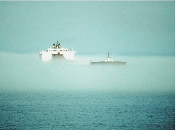 Fig1. A dense blanket of sea fog covers the route of this tanker. The bridge towers over the fog, but smaller vessels will be very hard to spot by the naked eye in this case. Source: zeilen.nl
Different types of fog
In contrast to sea fog, land fog is greatly influenced by diurnal cycles (one rotation of the earth). Compared to large bodies of water, the underlying landmass reacts more strongly to incoming solar radiation during the day and emitted infrared radiation during the night. Hence, radiation fog isn’t likely to occur over sea.Radiation fog
The principle behind radiation fog is as follows; when the air temperature drops, the boundary layer stabilizes while relative humidity increases. Once the temperature reaches or approaches the dewpoint temperature (Td) close enough the air becomes saturated with water vapor. This triggers a phase transition, where water vapor condenses into water droplets suspended in the air, basically forming a cloud at or near surface level. This process is optimized under calm high pressure conditions.The latter can lead to the formation of nocturnal fog, especially during autumn and wintertime when nights are longer. As the air temperature rises during the day in response to incoming solar radiation and winds increase as a result of the destabilizing boundary layer, the fog usually lifts or dissipates. If incoming radiation isn’t sufficient (in the middle of winter for example) the fog might persist for as long as there are no synoptic changes.
Radiation fog usually dissipates as a result of mixing with dryer air aloft, increasing surface winds due to synoptic changes, sudden covering with clouds and moisture transport to the surface below. The latter is optimized in mature fog fields where large droplets settle on objects near the surface or on the ground itself.
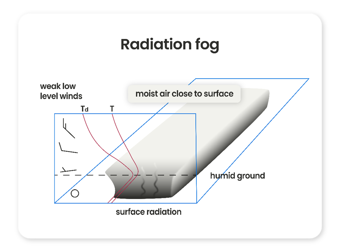 Fig2. Schematic view of radiation fog. Note the ground inversion, high humidity and weak wind (shear).
Advection fog
Another type of fog, which is the predominant one over maritime areas, is not linked to cooling of air near the surface. It arises when warm moist air is advected over rather low SST’s. This phenomenon is called advection fog and commonly occurs in spring and early summer over large bodies of water colder than the surrounding landmass.If warm air from the mainland moves over colder water, it creates strong inversions at low altitudes trapping most of the moisture underneath in a shallow maritime boundary layer, frequently leading to sea fog. In case of a descent background flow these situations are notorious for their strong low level wind shear. Sometimes an (intermittent) low level jet might even be present at the top of the boundary layer which can be identified by elevated oil drilling platforms or at hub height of certain wind farms sticking out of the fog below. In this dynamic setting temporal entrainment of drier air aloft might sometimes cause sudden localized dissolving of fog, which makes forecasting very treacherous.
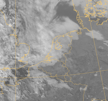 Fig3. Sea fog moving onshore in the Netherlands. The fog persisted offshore but dissolved quickly over land during the afternoon.
Near and in the wake of (warm) fronts a similar situation unfolds when moist subtropical air encounters rather cool water, in this case with much deeper saturated profiles. Therefore, this type of fog can persist with a fresh or even strong breeze, up to 5 or 6 Bft, whereas radiation fog usually dissipates or lifts when winds increase to more than 3 Bft.
This frontal type of advection fog is very persistent but eventually also lifts/dissipates, usually at much higher wind speeds or when encountering land/dryer air. Also, keep in mind that radiation fog develops under calm conditions with lacking wind (shear). Advection fog on the other hand, occurs when surface winds are moderate with strong low level wind shear and saturated neutral/stable profiles over considerable depths.
Fig4. Schematic view of a warm front accompanied by advection fog and low Stratus near and the in the wake of the surface front. Note the moist and neutral/stable profile and profound wind shear.
In the cold season, advection fog also easily forms over land when warmer maritime air comes in after a cold spell; creating very stable and moist conditions over melting snow and ice. Depending on SST these fog fields might survive offshore for some time as well.
Advection fog can also occur when the cooling processes responsible for radiation fog go into overdrive over snowy areas, especially when the air grinds to a halt under the influence of persistent high pressure. The continuous cooling occurring under clear skies might result in extensive fog fields which thicken over time. Once winds pick up slightly the fog is advected in the direction of the prevailing winds, usually lifting when reaching warmer water.
Evaporation fog
Another type of fog which occurs solely over open water is evaporation fog. This type heavily relies on cold air spreading out over warmer water. The resulting moisture transport from water to air occasionally results in patchy fog fields. Given the unstable nature of this setting and the involvement of cold and rather dry air, visibility usually doesn’t deteriorate as much and as widespread as with the previous types. Back in the day this type of fog was described as eerie, with pillars of fog erecting from the water below taking the shape of mysterious sea creatures, especially at night with poor lighting.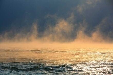 Fig5. ‘Smoking waters’ due to evaporation fog. Source: Meteoswiss.
Areas prone to sea fog
As we’ve seen, sea fog only occurs in humid and stable/neutral atmospheric settings with inversions rather close to the earth’s surface (evaporation fog not included). Zones where ocean currents allow cold water from the depths to swirl up towards the surface are notorious for their semi-persistent fog risk.Think of the Labrador current for example, or upwelling W of South America and along the coast of California. Also, a bit closer to home, W of the Iberian Peninsula and NW Africa. Combined with prolonged high pressure influence (with weak low level divergence and high T(w)850) these areas are prone to see fog for considerable periods of time. Old frontal structures captured within such high pressure dominated areas are also prone to fog. This can happen virtually anywhere.
Also, near and in the wake of warm fronts the risk of fog increases. As described, especially later in the winter and during springtime. Nearshore locations can also be prone to fog as radiation fog on land occasionally rolls offshore, causing quick deterioration of workability and/or accessibility of the work site while conditions remain quite well further offshore.
Always on the lookout
At Infoplaza we are well aware of the restrictions sea fog can impose on your maritime operations. Hence, our forecasters are always on the lookout for synoptic setups favorable for the development of sea fog, in order to reduce downtime and keep the personnel and assets of our clients safe and sound. Do you want to know more? Feel free to contact us at any time.