The Intertropical Convergence Zone (ITCZ) is a region near the equator where trade winds from the northern and southern hemispheres converge and rise, creating a zone of low pressure. This band of low pressure is characterized by increased convective activity over a large area. The exact position of the ITCZ is not fixed and changes with the seasons. It's a major factor in the formation of tropical cyclones, and it's a main driver of the well-known monsoon.
Trade winds
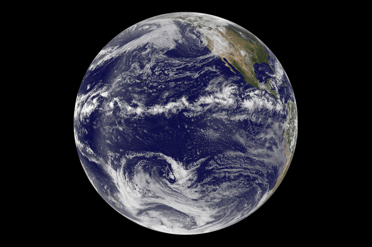
Trade winds are persistent winds blowing from the subtropics towards the equator on both hemispheres. On the northern hemisphere, trade winds blow from the northeast and on the southern hemisphere from the southeast. These trade winds meet around the equator, where the air is forced to rise. This rising air creates convective instability. When trade winds are strong enough, strong rain showers and well organized thunderstorms are able to develop. In places where trade winds are weaker, smaller and more isolated clouds will form. This belt of clouds around the equator is clearly visible on satellite images (see image 1).
.png?width=900&height=600&name=nasa-goes-earth-doldrums-00_0%20(1).png) Image 1: The ITCZ is visible as a clear band of clouds near the equator over the Pacific Ocean.
Image 1: The ITCZ is visible as a clear band of clouds near the equator over the Pacific Ocean.
The role of the sun
The exact position of the ITCZ is linked to the sun’s relative position above Earth’s surface. During the northern hemisphere’s summer, the sun is at its northernmost, causing increased heating and rising air further northwards. In contrast, during the northern hemisphere's winter, the sun is at its southernmost point, leading to increased heating and rising air further southwards. During the year, the ITCZ shifts north and south, depending on where the sun's energy is strongest (see image 2).
The ITCZ shift over land is much larger than over the ocean. This is due to the fact that land heats much faster than the ocean, which has a large heat capacity. The ITCZ follows the sun with a delay of approximately 2 months. When the sun reaches its northernmost point in June, the ITCZ reaches its northernmost point somewhere in August. This seasonal migration of the ITCZ affects the distribution of rainfall in many tropical regions, making it an important factor in global weather patterns.
.png?width=940&height=529&name=image%20(13).png) Image 2: The average northernmost and southernmost position of the ITCZ. Notice the difference in position between land and ocean.
Image 2: The average northernmost and southernmost position of the ITCZ. Notice the difference in position between land and ocean.
Tropical cyclones
Strong thunderstorms are able to develop over West Africa when the ITCZ is at its northernmost position. These storms are often the trigger for hurricane development during the Atlantic hurricane season. When clusters of these thunderstorms are transported onto the Atlantic Ocean by the easterly trade winds, these thunderstorms can develop into a tropical storm or even a hurricane under the ideal circumstances.
Monsoon
The ITCZ also has a significant effect on the monsoon. During the northern hemisphere’s summer, the ITCZ migrates north, bringing heavy rainfall to regions like India and West Africa. The wet season often results in 75-90% of the total annual rainfall in those areas. During the northern hemisphere’s winter, the ITCZ migrates south, bringing heavy rainfall to regions like Indonesia, northern Australia and southern Africa. The ITCZ's position and intensity play a major role in determining the monsoon's timing, location, and amount of rainfall, as it acts as a "monsoon trough" that helps to steer monsoon winds and rainfall. A stronger ITCZ can lead to a more intense monsoon, while a weaker ITCZ can result in a weaker monsoon.
Importance for marine operations
In conclusion, the ITCZ is highly influenced by the sun and the presence of trade winds. The ITCZ is a critical component of global weather patterns and plays a significant role in determining the timing, location, and intensity of weather phenomena like thunderstorms and tropical cyclones. Understanding its behaviour and effects is important for marine operations, because it also affects the ocean conditions in the (sub)tropics. The zone's heavy rainfall and thunderstorms can create rough seas and hazardous conditions for ships and other marine vessels. The ITCZ can also affect wind patterns, causing unpredictable and changing winds that can impact navigation and the efficiency of sail-powered vessels.
Weekly weather briefing
Every week we will post an updated weather briefing on the Infoplaza website and the Infoplaza Marine Weather Operations LinkedIn page. We will also share weather related articles and topics on offshore weather on these pages. We hope all our clients stay safe at sea this week. Please feel free to contact us at any time if you have any questions or remarks.


