The wind funneling effect in marine weather refers to the phenomenon where wind speeds increase as air is forced through narrow passages or constricted areas, such as between islands, through mountain passes, or along coastal regions with specific topographic features. This effect can significantly influence local weather and sea conditions, making it crucial for marine navigation and operations.
Background
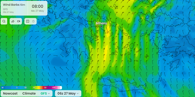
Wind flows from high pressure to low pressure. However, due to the Earth's rotation, this movement doesn't occur in a straight line. Instead, wind circulates clockwise around high-pressure areas and counterclockwise around low-pressure areas. Over open sea, the wind is fairly uniform over large areas due to a relatively smooth Earth surface without major obstacles. This is generally not the area where wind funneling occurs. It often occurs in areas with complex and variable terrain, such as mountains and valleys, in between islands and along the coast. However, buildings or offshore structures may disrupt the local wind flow as well, be it on an even more localized scale. These obstacles force the wind to change direction and can cause the wind to funnel through narrow passages or will act as channels that guide the wind along a specific path.Some examples of larger and well-known areas that are prone to wind funneling are: fjords (all over the world), the Greek islands in the Aegean Sea (also called the Meltemi winds; see figure 1), southern France (also known as the Mistral wind) and many more.
 Figure 1. Wind funneling over the Aegean Sea. Strong wind occur as the wind is ‘squeezed’ between the many islands. Image: I'm Weather.
 Bernoulli’s principle
Before wind enters a narrow passage, it has a specific air pressure and speed. As it passes through the constricted area, the pressure decreases and the wind speed increases. This relationship between pressure and velocity is known as the Bernoulli’s principle. The principle, originating from aerodynamics and hydrodynamics, was first described by Swiss physicist Daniel Bernoulli in the 18th century. It is now also known as the Venturi effect or, in general, wind funneling.

Figure 2: The venturi effect explained in a graphic.
Impacts and challenges
The main impact of wind funneling on marine weather is a significant (and sometimes sudden) increase in wind speed in a localized region, affecting offshore operations. As a result of these higher wind speeds, more turbulent sea conditions can be expected as well. Furthermore, these local changes may also affect the local weather in terms of enhanced convection (easier development of rain showers or thunderstorms).Understanding the wind funneling effect is vital for marine weather forecasting, offshore planning and navigation. By recognizing areas prone to this phenomenon, better preparations and safety measures can be taken for the potential challenges and hazards posed by increased wind speeds and rough sea conditions.
But it’s not easy to predict for forecasters, as the funneling effect poses significant challenges. Several factors make it difficult to predict exactly when and where funneling will occur, and how intense the effect will be:
- Complex topography: it is hard to predict how the wind will interact with these feature exactly.
- Small-scale phenomena: it is generally a localized event, especially in case of building and offshore structures which are not taken into account in weather models.
- Rapid changes: wind speed and direction can change quickly over time.
- Limited observations: observations are sparse in some areas, making it hard to monitor conditions and to validate the models.
- Model limitations: some localized wind effects are smaller than the model resolution.
Conclusion
Though wind funneling is an often localized phenomenon, it may pose large threats to marine operations in these prone areas. Understanding and predicting wind funneling are essential for safe and effective marine operations. Even with high-resolution models and experienced forecasters, it still remains a challenging expertise.


