Thanks to a ridge of high pressure, workable conditions are expected over the North Sea until Thursday. Conditions will change from Friday as low-pressure areas may begin to influence the weather. Winds will shift to S-SE and increase, though the timing and strength of these changes remain uncertain.
A high-pressure area currently positioned over central Europe is shifting further southeast, maintaining a ridge over the North Sea. This ridge will weaken by the end of the week. Meanwhile, low-pressure systems develop over the Atlantic and slowly move east during the weekend. By then, high pressure will be positioned over eastern Europe, leading to a south to southeasterly flow over the North Sea. However, the strength of this flow remains uncertain, especially in the northern North Sea, as it depends on the depth and track of the Atlantic low-pressure systems.
Thanks to the ridge of high pressure, workable conditions are expected for the coming days. Significant wave height will remain around 1.0 meter or lower in the central and southern North Sea until Friday, with a possible increase to 1.0–2.0 meters in Forties and Viking on Thursday.

Uncertain weekend ahead
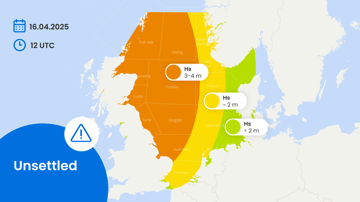
What will happen during the weekend remains uncertain. Waves are expected to increase, most likely to 1.0–2.0 meters in the southern North Sea, while in the north, significant wave heights could reach 3.0–4.0 meters.
We plan to post this weather briefing on our Infoplaza for Marine Weather Operations LinkedIn page as well. This is also the place where we will share other insightful marine weather articles, so be sure to follow us to never miss an update.